

Discover a powerful photography companion with MapCam, the application designed to give your images precise geographical context. Capturing and cataloging moments becomes seamless and organized as the app enhances your traditional camera experience, allowing you to store and manage photos with an added layer of informational richness.
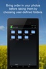
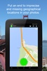
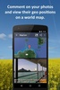
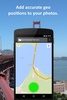
Enjoy the convenience of selecting storage folders before you snap a picture, ensuring your photos are neatly categorized from the outset. The application integrates geotagging by embedding accurate GPS coordinates, including latitude, longitude, and altitude, directly into your photo files’ Exif data. This means you can view your images on a world map, transporting you back to the exact place where you took them.
Beyond geolocation, the software enables you to enhance your photos with descriptive captions, saved within the IPTC metadata, ensuring your precious memories carry personalized narratives that remain with the image file. These features work with an array of popular camera apps, providing flexibility and ease of use.
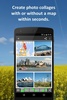
Create striking geo photo collages to visualize your adventures on a map, complete with your visual memories. Sharing your geotagged photos is effortless, with compatibility across various platforms such as email, social media, and cloud storage services.
Simplicity is key with this tool. Accessible with just a click, the user interface indicates GPS signal precision and activates your chosen camera app to take the picture, automatically recording the best position data available.
For anyone who values the context and details of their photos, MapCam is essential. Ideal for travel, events, outdoor activities, or for use in different professional fields, it ensures your images are more than just pictures—they're stories with accurate geographical chapters. Enhance your photographic journey with MapCam, where every picture is a mapped memory.
Requirements (Latest version)
- Android 4.4 or higher required
Comments
THIS THE BEST APP TO SAVE PHOTOS WITH LOUCITON